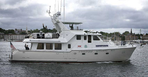
Nordhavn 57 En Route to Gjoa Haven
 |
For the past several weeks BoatTEST has been following professional filmmaker Sprague Theobald on his epic adventure through the Northwest Passage. Last week we left the crew of the Nordhavn 57 as they traveled through Devon Island. This week we joined them as they arrived at Beechy Island, passed through Bear Point and patiently waited for the ice to melt so they could continue pursuing their ultimate goal.
The material published here has been excerpted -- and highly edited for reasons of space -- from the blogs of Sprague Theobald as they appear on his website, www.northwestpassagefilm.com. We urge you to visit the website and read the blogs in their entirety.
Read the 1st installment of the saga...
Read the 2nd installment of the saga...
Read the 3rd installment of the saga...
 Beechy Island |
August 4 Post – Arrived at Beechy Island
We arrived at Beechy Island yesterday around 2:00 in the afternoon in a dieing breeze. The weather window has held beautifully for us and it’s my dire hope that these days of grace extend through the Bering Sea! Beechy Island is a “ground zero” for me. This whole trip/documentary has been to travel the passage, but the fact that this was the last true known area where the Franklin Expedition was intact, for me, is the hallowed of the hallowed. Hundreds of lives have been lost trying to find this passage but no expedition has garnered more attention and mystery than that of John Franklin’s. Long story short, he left England in 1850 with two ice proven ships (they were the ships that “discovered” Antarctica) with 128 men. The expedition was to last two years. Neither the men nor the ships were ever heard from or seen again. Over 30 international expeditions went in search of the missing Franklin Party. Apart from some artifacts that local Inuit had, an occasional found pile of sawed bones (suggested cannibalism) and an extremely confounding note which was left in a cairn on King William Island, Franklin’s Expedition remains one of history’s largest mysteries.
For their day, these men were international heroes, not unlike our astronauts. Their ships were the equivalent of say, our Gemini program, state of the art. Their complete and utter disappearance would be akin to that of Neil Armstrong landing on the moon and simply vanishing. I am extremely humbled and awe struck that Bagan now rests on her anchor in the very bay Franklin’s two ships, the ‘Erebus” and the “Terror” were trapped in the ice for two years.
Once settled in, the shore and filming parties were arranged. Greg and I broke out the dry suits and did an hour long dive. The bottom is as featureless as the landscape here; it’s flat and seemingly goes on forever. Small sea urchins and clams pock-mark an otherwise devoid ocean floor. The water was 40 degrees and the visual around 80’. After a little over an hour we surfaced with some fantastic HD footage (each day’s coverage gets better and better!) of a very intriguing bottom feature. Even though we have underwater communications with each other as well as the surface it was extremely reassuring to surface and see Sefton, Chauncey and Dom’s smiling faces. Clinton was manning the underwater coms and was also in charge of polar bear watch with rifle at the ready. Shortly before I surfaced I remembered a comment I heard in Halifax regarding polar bears; “If you see one, the chances are that he’s been hunting you for quite a while.” They’ve been seen swimming over a hundred miles from land.
 Bear Point |
August 5 Post – 900 miles from the North Pole
We left Beechy Island yesterday, but before we did we downloaded some ice charts for Resolute. Seems the pack ice has come in again so we need to wait for this to clear. The pump we had Niad ship for the hydraulics isn’t arriving (he writes with all fingers crossed… good trick if you can do it) until Friday so no big rush to get in there. With this in mind we decided to head north about thirty miles for Bear Point. The thinking behind this was nothing cleverer than to say we crossed the 75th parallel, which would put us about 900 miles from the North Pole. We’re now anchored farther north than any town or city in the northern hemisphere (I think I have my facts right on this but if not, am sure I’ll hear about it soon!). So, here we sit on the hook at Bear Point, waiting out a small blow and catching up on sleep. The landscape is absolutely barren and forbidding, it looks like some of the pictures from the surface of Mars. Only when you truly look for it can you see any real evidence of vegetation (dwarfed at best) otherwise it’s harsh, desolate and incredibly lonely. The air temps are still in the low 40s but the wind chill is definitely in the mid 30s, water temp is 38. Going to try and find a good excuse not to dive today.
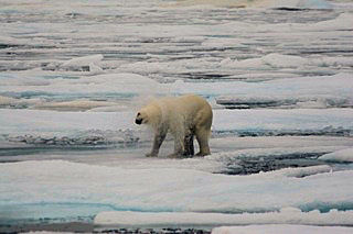 Another polar bear. |
August 7 Post – Somerset Island
The plan was to get to Resolute, pick up our part sent by Niad, do some light provisioning and find the crew unrestricted internet access. Someone forgot to let Mother Nature in on our plan. We first encountered the ice sheets and fog about 2:00 in the afternoon and as the day rolled on they became heavier and more permanent. The wind had been blowing out of the east for the past few days and was forecast to do the same through the 10th, allowing any ice in the general area that wasn’t permanently nailed down to head back toward Resolute. At 8:00 PM we arrived about two miles off the harbor entrance and try as we may we couldn’t find a lead or opening in. (We did happen to see this guy though – see attached picture shot by Greg DeAscentis- who was pretty entertaining). It was our collective and sober reasoning that even had we found an opening there was no knowing how much ice, if any, would be blown into the harbor itself and how long it could trap us there… or worse.
Around 9:30 PM we pointed the boat south down Peel Sound where we currently sit on anchor in a small cove on the west side of Somerset Island. The good news is that this gets us closer Cambridge Bay where we plan to refuel and have the Niad part sent; the bad news is that the central ice (about 50 miles away) still hasn’t broken up and as of right now it’s impossible to get there. For the first time since we left Newport I’m starting to explore the grim scenario of the ice simply not opening up this year. Having said that I have to admit that this thinking is a bit premature and we’re still a bit early to enter. Also, there’re no indications that this year will be any less likely to open than last year, but nonetheless the thought adds to the myriad of other nagging ones (don’t ask) that swirl around my addled brain at 2:00 in the morning.
August 9 Post – Tucked Away in Young Bay
We’ve made our way a bit further south down Peel Sound and are tucked away in Young Bay, a protected anchorage a little less than halfway down the east side of Prince of Wales Island. We’re not going anywhere in a hurry as the ice south of us in the central part of The Passage simply isn’t moving or breaking up. Every few days, via email, we’re in touch with Peter Semotiuk in Cambridge Bay seeking his wise council on all things ice related. For years now, Peter has been the “voice” who the majority of the boats trying to do this trip turn to, to plan their routes and timing and has built a wonderful and well deserved reputation for himself. It’s his feeling that if the ice clears it may still be a few weeks off. I first learned of Peter in the fascinating book “Arctic Passages” by John Bockstoce. If you haven’t had the chance to read this or John’s other book, “High Latitude, North Atlantic” make sure you do as they’re both truly remarkable books about a place that, as I’ve said before, defies description. “Arctic Passages” is about John’s transiting the arctic in a thirty-two foot walrus hide canoe. It makes our effort aboard Bagan seem like we’re on a luxury liner. A few days before we left Newport John came by Bagan introduce himself and it’s one of the few regrets of this project that I wasn’t around to meet him. So, here we sit, one eye on the ice charts, the other down the road with all fingers crossed that we’ll soon see or hear about a break in the ice. Trust me when I say “you’ll be the first to know”.
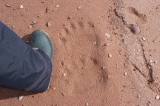 Fresh polar bear prints. |
August 10 Post – You're Never Alone
Still in Young Bay, waiting for the ice to melt (grass to grow? paint to dry?). We downloaded ice charts last night as well as this morning and the difference we saw was quite remarkable; the central area of The Passage seems to be breaking up before our eyes. We had a good breeze from the SE last night and unless the satellites were wrong, this breeze seemed to open the skinniest of leads, a great first step. For now we’ll sit tight and see how it all develops. Last night Chaunce, Clinton and Sefton went ashore to poke around and see what was what. The landscape has flattened out considerably around here allowing one to see for miles in most every direction. They came back saying that they hadn’t seen as much as a field mouse. Today Dominique, Chauncey and I took a quick walk on the shore. Last night’s tide had washed away the previous group’s footprints and in their place we found these fresh polar bear prints. They might have not seen anything, but it’s our concern that something might have seen them. Suffice it to say we never go ashore without guns.
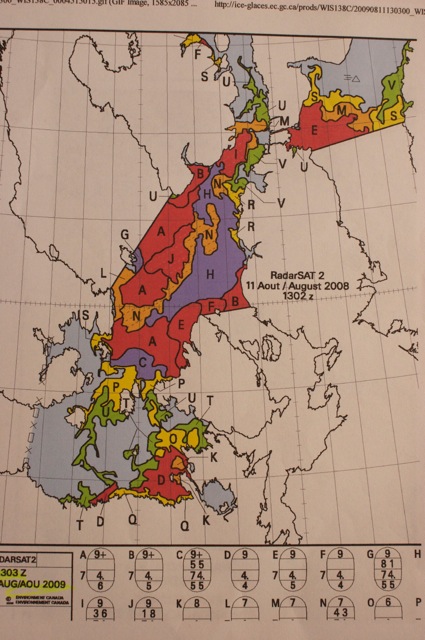 Weather map. |
August 12 Post – We Continue To Wait...
The accompanying picture is a representation of the subject of all our attention; an ice chart from The Canadian Ice Service. We download these charts once a day and try to get a picture of the speed and direction of the ice melt. The areas in red are 9-10/10ths ice, yellow are 7/10ths and the areas in green are 1-2/10ths ice, the later being ice that we can move through with very little problem. If you look closely to the upper right of the large, red area you can see a lot of green with even some blue (we’re just to the upper left of this area), this was red only a few days ago. This is good news in that a lead is opening up for us, but not quite ready. Unusually high temperatures and an expected NE breeze will help open this even more giving us a clear run down to Gjoa Haven in perhaps four to five days. Obviously this isn’t anything we want to rush so, we continue to wait; we read, sleep, eat, read, sleep and eat… and try to give one another as much space as possible.
August 12 Post – Great News!
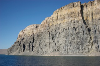
The noon ice chart showed us what we’d all been keeping our fingers crossed for; in the past 12 hours the lead we’d been keeping our eyes on had opened considerably and there was no denying it was time to go! We traveled south about fifty miles and are now on the hook in False Straight. Amazing how a small hop like this can have the topography and landscape change so much. Where we were, on Pandora Island was rolling, beautiful and almost meadow-like. We’re now anchored in a stony bay that seems more like Ireland.
At midnight last night we had a stunning sunset, something we haven’t seen in quite a while, all cameras were out and mouths agape. The orange and reds of the western horizon were bouncing off the cliffs to our east, amazing. Last night’s ice charts again showed that the lead has opened up even a bit more so today we’re going try and add another fifty or so miles of southing. There is still ice in the Sound and at times we have to pick and plot our way through it, but with six sets of active eyes it’s, so far, been very manageable. During our trip down yesterday we had the extreme pleasure of being entertained by a remarkably curious polar bear on one of the ice flows. This guy was amazing in that he literally struck every pose going; he was completely oblivious to us. He stood up on his hind legs, he pawed the air, he sat on his haunches and scratched his belly, he crouched as though he was going to spring, he hopped from ice sheet to ice sheet and finally after scratching behind his ear he lay down and curled up to go to sleep. So, with one eye on the ice charts, one eye on the wildlife and another on the road ahead, the trip of a lifetime continues.
 |
 |
August 15 Post – Headed to Gjoa Haven
Last night the ice charts showed us what we’ve all been waiting for; a solid lead in the ice had formed on the west side of the Sound. This was just what we needed to make the big jump down to Gjoa Haven. Two days before we’d dropped the hook in Pattinson Harbor, an incredibly beautiful and deep fjord-like indentation on the coast that ran east around four miles to a fresh water lake. While here we had a chance to rest, observe caribou and even another polar bear this morning. Even though the water was 31 degrees and the air 34, the tall, steep hills were showing more and more evidence of green undergrowth, a sure sign that we’ve been heading further south.
Almost immediately out of the harbor we ran into what we hope is some of the last sheet ice, this rated at 3 – 4/10ths. As the accompanying pictures show, we put Sefton and Chauncey up on the radar arch for the day from which they communicated with the pilothouse as to the best lead to take to head through this last bit of blockage. As the 2nd picture shows, these small openings which lead to the larger openings weren’t always obvious and several times we had to stop, push a pack of ice out of the way with a boat hook, or take advantage to the prop-wash and or bow thruster wash to clear our way out. As I type this the larger lead is about five miles off and after that it “should” be clear for sometime to come. Maybe Gjoa Haven in two more days, our first community of any size since we left Greenland.
Next Week: Gjoa Haven
Editor’s Note: Nordhavn has discontinued the Nordhavn 57, but to see the vessels have replaced it visit the Nordhavn website... http://www.nordhavn.com/