Nordhavn 57 Makes It to Greenland
Last week we left the crew of the Nordhavn 57 as they made their way to Halifax, Nova Scotia on the first leg of their quest for the Northwest Passage. The trip so far has been a piece of cake, but now the good ship Bagan will have to start braving the strong tides and capricious weather in the Canadian Maritimes and beyond. What is it like to power in these waters? What sort of precautions need to be taken? What sort of weather service do you need? These questions and others will be answered by the owner of the Nordhavn 57, Sprague Theobald.
For those who missed last week’s installment, 57-year-old Sprague Theobald who is a professional film maker had decided that this is the year he was going to take his Nordhavn 57 through the fabled Northwest Passage. (After all, he isn’t getting any younger.) Last week he recounted his trials and tribulations in getting ready to mount this incredible cruise, and this week he describes the first difficult leg of his journey, which was from Halifax to Nuuk, Greenland. The material published below is excerpted from Theobald’s blogs which appear on his website, www.northwestpassagefilm.com. The passages here have been highly truncated, so to get the complete version and to see all of the pictures and videos made along the way we urge you to visit Theobald’s website.
To read last week’s beginning installment of the saga…
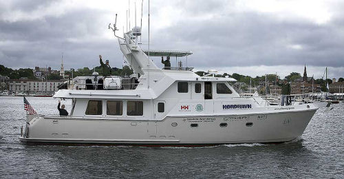 The Nordhavn 57 Bagan leaving Newport, RI on June 16, 2009, on its way to the land of the midnight sun. |
June 21 Post – Crossing the Bay of Fundy
Four hours outside of Halifax and the weather holds; long, fat swells from the SSE, winds light & variable and not a cloud in the sky. Yesterday, as we made our way past the Bay of Fundy, we felt the influence of its legendary tides. We were approximately 80 miles to the south of the bay and found that the set was so strong it knocked us about five degrees off course. This leg to Halifax was basically a shake-down leg to, as Gerry Driscol used to say on “Intrepid”, “See what we can break.”
Computer Info
Nothing truly broke but we did have two problems. The first being the computer... again. It’s a Dell tower, a few years old and just doesn’t seem to be up to the task of running several high demand programs simultaneously. We have the electronic Nobeltec charts, an Airmar program which via an outside sensor gives us not only wind speed and direction but temp, a barometer, wind chill, apparent wind and satellite availability (Airmar is one of the more amazing marine innovations of the last five years).
Learning about Fuel Pick-Ups
The other small problem occurred at 5:00 this morning and was operator error. In the three years I’ve owned Bagan I never quite realized that the fuel pickup lines are a few inches off the bottom of the tanks, which only makes sense. These pickup lines think that the tank is empty when there’s actually about 15 gallons showing in the sight gauge. You can guess the outcome. We’ve three other fuel tanks aboard and 20 minutes later we were underway having been soberly being reminded that complacency is always lurking.
June 23 Post – Waiting for Weather in Halifax
Still in Halifax and most probably will be here for the next few days. We’ve been watching a system develop off-shore and last night it came ashore as a pretty fair n’or easter; driving rain, gusts 35 – 40 kts and all in all a good time to be out of harm’s way. From what Clinton’s been pulling up on the weather charts it seems this low will be lurking for the next few days with the strongest part of the system coming in this afternoon. We’re going to move Bagan to an inside wall here at the marina, button up and hunker down.
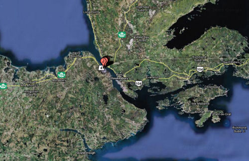 The Canso Canal runs between Cape Breton and Nova Scotia. The famed Bras ‘d Or lakes are in the upper right. The whole area is prime summer time cruising ground for yachtsmen. |
June 27 – At the Canso Canal
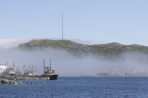
Yesterday, at of 3:00 PM local time, we locked through the Canso Causeway, left the foggy Atlantic behind and sailed into the sunny Gulf of St. Lawrence. 70 degree air temps & 65 degree water temps were far from what any of us expected as we took this next measured step toward the arctic. The causeway itself is a fairly straightforward lock-in/ lock-out canal configuration but its role and purpose anything but. It was originally constructed to help control the six to seven knot current which races through the cut, impeding all but the largest traffic. In conjunction with this was the adjacent building of Point Tupper, one of the deepest commercial ports on the east coast of America. The port hosts facilities to some of the largest oceangoing oil super tankers known, two of which were currently in. Trying to make up some of the time we lost while in Halifax we powered through the night and as the familiar fog once again rolled in we dropped the hook at 5:00 AM, just off the beach at Harve-Aubert on the Iles de La Madeleine.
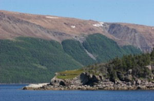 Newfoundland coast. |
June 29 post – West Coast of Newfoundland
Yesterday morning at 10:00 we left Harve-Aubert to head out across the Cabot Straights and up the west side of Newfoundland. “They” called for 10-12kt breezes and slight chop; Mother Nature failed to get the memo. By 2:00 in the afternoon we were in 30kt southerlies blowing steadily against the tides pouring out of the Gulf of St. Lawrence. The nasty combination of wind against tide lead to four to six foot “chop” with steep waves running up in excess of ten feet. At 3:05 PM, “Bagan” performed the balancing act of her lifetime as she sat atop one of the larger, steeper waves, trying to make her mind up whether she was going to tumble onto her beam ends off the back of the wave or stay put and ride the crest back down again. A collective sigh of great relief was let out as she chose the later.
It continued to be a nasty night but as we powered into the lee on the southwest side of Newfoundland the unexpected weather slowly released its grip and by 7:00 this morning we were finally moving through the forecasted “chop”. How Dominique managed to produce a full dinner for us last night is still a complete mystery. Two hours ago we entered the Bay of Islands and are now sitting on the hook in a stunning and very secluded North Arm Harbour, more a mini-fjord than actual harbour.
The gentle waterfalls that run down the steep green hills which face either side of this cut are a soothing and welcome relief to the thrashing we took yesterday at this time. Clinton’s keeping an eye on a southerly system which promises 35+ kts out in the straight, but for the next few days anyway we’ll be day-hopping up the west side of Newfoundland protected by her lee with hopes of arriving in St. Anthony’s in three more days.
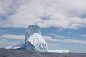
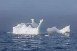 It was bigger than it looks. |
July 1 Post – St. Anthony’s
Dominique was the first to see it on radar; an extremely large target which wasn’t moving, especially out of our way. We’d left North Arm at 10:00 AM on June 30th and 18 hours later entered the Straight of Belle Isle. It’d been a picture perfect day in which we hugged the western lee shore of Newfoundland while it blew a gale on the east side. Catching up on wash, reading and rest we’d enjoyed the flat waters to no end. We’ve worked our way far enough north so that the sun sets around 9:45 PM and rises again around 3:30 AM, never experiencing total darkness.
Berg Ho!
Running through the night a heavy fog had settled in around 2:00 AM giving an ethereal feel to a light not quite twilight nor dawn. Yet what was now showing up on the radar four miles to the north was so large nether fog not low light could hide it; our first official sighting of an iceberg was an amazingly impressive one in that this berg had to have been at least 1,000 feet long and over 100 feet high. There was no doubting that it was a truly a mountain of ice and as the minutes ticked by our sighting was confirmed by the presence of several others, albeit not half as large, mini-islands of ice.
In the Fog
Once again, as many sets of eyes that were available were glued to either one of the two radars as ice targets and bearings were called out to the helmsman of the hour. No exaggeration to say that there were five sets of nerves on a knife edge. With a heavy fog allowing us no more than 50 yds visibility at any given time we felt our way along the coast and entered the small and beautifully green harbor of St. Anthony’s around noon. We’ll be here on the hook just long enough to download some weather charts hoping to find a good window make the 800 mile passage across to Greenland. We know that there’s plenty more ice out there but it’d be nice to shake some of this fog to make actual visual contact instead of that on the radar... but I’m not complaining!
 St. Anthony, Newfoundland is a harbor of refuge from the North Atlantic. |
July 6 Post – Weather in at St. Anthony’s
We’re still in St. Anthony’s, pinned down by an extremely persistent and sluggish low pressure system just off-shore. Each time we download weather charts it suggests that it’s about to move on, but six hours later the next download of charts shows that it once again threw us a very successful head-fake. By six hour increments the charts give us prognostications for five days out and even looking down the road that far, there it sits, looking back at us; I wouldn’t say taunting but certainly not enticing.
As I write this, stuffed down into my sleeping bag, holed up in my cabin, I can hear the screeching of the cold, pre-arctic winds outside. I caution a peek at the wind gauge on the bulkhead next to me and see a sustained breezes in excess of 40kts. We’ve been here longer than first planned and will most certainly not be leaving for at least another five days.
 |
July 10 Post – On to Nuuk, Greenland
For the past week we’ve been hunkered down in a small northern cove of St. Anthony’s, Newfoundland. As mentioned before it was a small but persistent low pressure system which, having parked itself a few hundred miles away to the east in the North Atlantic, kept us from starting this next leg, Newfoundland to Nuuk, Greenland. Two nights ago the weather charts showed a small high pressure system developing just north of us and yesterday morning’s charts showed it again, if not a bit larger. This was what we’d been waiting for eight days while anchored.
Yesterday morning we downloaded the weather chats again and were ecstatic to see that the high pressure had gotten large and in doing so created a perfect weather window for our crossing. And that’s just where we are now, around 200 miles out, heading for Nuuk and thoroughly enjoying relatively flat seas, less than 10kts of breeze and only the occasional pocket of fog. Right now the ETA for Nuuk reads 7:30 PM on July 13th. A lot can change this arrival date but for now life is good (hell, it’s always good) and we’re back on the road to Nuuk, Greenland. By the way, the ocean temp is 38 degrees and outside the air is 34.
 Nuuk, Greenland |
July 14 Post – Nuuk at Last
After 5 days at sea we arrived here in Nuuk, Greenland safe and sound late yesterday afternoon with a southerly at our heels. The weather window we were watching held as promised for the first three days and the crossing from Newfoundland to Greenland was as straightforward as hoped for; winds light & variable and seas benign. As expected, during the final evening the wind started to fill in from the SSE. Very quickly the seas built and winds punched in 25-30 kts. For the whole crossing we were pleasantly surprised as to the general lack of icebergs but as we closed in on Greenland we started to pick them up on radar more and more. During the day it’s usually no problem as even the smaller pieces, the growlers can be spotted. Nighttime was were our concerns lay as even radar has its limits.
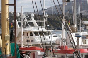
The main harbor of Nuk is primarily a commercial harbor and you basically tie up wherever you can find an opening. We currently lay alongside a work barge, which lays alongside a 100’ Greenlandian (?) wooden fishing trawler, which itself lays alongside an 80’ Norwegian steel trawler which is tied to a steel bulkhead. Just now a 65’ French steel ketch tied up outside of us. Our hope to hop to the fuel dock this afternoon is going to take the unbridled cooperation of four different nations.
Watermaker Trouble
A Couple of Very Unexpected Low Points: Our brand new, budget-busting, $14,000, Sea Recovery, Aqua Whisper, watermaker crapped out after less than 30 hours of use. Basically it started to divert all newly made fresh water overboard and not into the tank. What water we were making was going right back into the ocean. Clinton found a work-around and although we are making water I’m not real happy… to put it mildly. The guys who installed it, Ocean Options, have been great about helping us diagnose the problem (control panel?) but the product’s reliability is deeply concerning. The cost of the unit was a brutal hit to the trip’s budget and the fact that we’re heading for an area not known for it’s ample marinas is very unsettling.
Nobletec is Not Cheap
Also; last year I bought the upgrade package of for our Nobeltec electronic chart system. As expected we now need to buy a “key” to unlock their World Folio of charts on the system. These charts include Greenland, The Arctic, as well as Alaska. That’s fine. We called Nobeltec to purchase the key and it’s my understanding that in order to access the World Folio we now have to buy their newest upgrade as the one we bought last year in no longer valid. We have all the paper charts aboard that we need but in order to access them on the computer I now have to buy yet another upgrade... again.
Next Week: Nuuk to the Gate way to the Northwest Passage.
Editor’s Note: The Nordhavn 57 is no longer in production, however if you would like to see her replacement and get all details, go to the Nordhavn website... http://www.nordhavn.com/